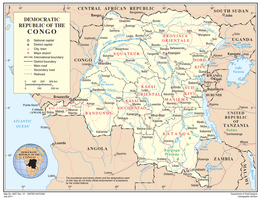
Democratic Republic of Congo
The Democratic Republic of the Congo (French: République démocratique du Congo), commonly referred to as DR Congo, Congo-Kinshasa or the DRC, is a country located in central Africa. It is the second largest country in Africa by area and the eleventh largest in the world. The country straddles the Equator, with one-third to the North and two-thirds to the South. The size of the DRC, 2 345 408 kms2, is slightly greater than the combined areas of Spain, France, Germany, Sweden, and Norway.
With a population of over 72 M (2012), the Democratic Republic of the Congo is the nineteenth most populous nation in the world, the fourth most populous nation in Africa, as well as the most populous officially Francophone country.
The DRC borders the Central African Republic and South Sudan to the north; Uganda, Rwanda, and Burundi in the east; Zambia and Angola to the south; the Republic of the Congo, the Angolan exclave of Cabinda, and the Atlantic Ocean to the west; and is separated from Tanzania by Lake Tanganyika in the east. The country has access to the ocean through a 40 km stretch of Atlantic coastline at Muanda and the roughly 9 km wide mouth of the Congo River which opens into the Gulf of Guinea.
The whole of the country lies within the basin of the river from which it takes its name, a huge and often swampy area with an average altitude of only 400 m, the lowest points being found in the north-west in the region of Lakes Tumba and Mayi-Ndombe (previously Leopold II), toward which the main left-bank tributaries converge. The central depression is open only to the west, but is enclosed by a higher rim in all other directions. In the north, flat plateaux between 600 and 800 m in height lie between the Congo and Obangui Rivers.
In the south, huge, tiered plateaux rise steadily towards the south-east, reaching 1000 to 2000 m in Shaba province. In the east the old hard pan protrudes around the major depressions of the western Rift Valley. Peaks reach 4500 m in the Virunga volcanic massif on the border with Rwanda, and exceed 5000 m in the Ruwenzori Mountains on the border with Uganda. They reach 2000 m in the Blue Mountains, west of Lake Albert and in the Kivu Mountains, west of the lake bearing the same name (according to the Jeune Afrique atlas). A total of 77% of the country is at an altitude of over 1000 m, but only 0.8% is over 2000 m.
The Congo (Zaïre) River dominates the country. At 4374 kms, the Congo is the second longest river in Africa and the seventh longest in the world. The Ubangi River is the Congo’s chief northern tributary, while the Kasai is its main southern tributary. Other rivers feeding the Congo are the Luvua, Aruwimi and Lomami.
Except in the high elevations, the country’s climate is very hot and humid. The following climatic zones can be distinguished (US Department of State):
- A permanently hot and humid equatorial climate near the equator, with 140 to 160 days’ rain a year, with maximums in April and October and minimums in January and July. The average annual temperature in the low central area is about 27° C. Temperatures are considerably higher in February, the hottest month. In low-lying areas (the river basin), annual rainfall is between 1800 and 2200 mm.
- A tropical climate beyond latitudes 3° North and 3° South, with a dry season that increases in length with the distance from the equator (4 months at Kinshasa, 5 months at Kamina and 6 months at Lumumbashi);
- Variations depending on altitude in the mountainous regions in the eastern Kivu and Shaba provinces, where rainfall can be as high as 3000 mm and average temperatures drop by 1° C for each 180 m rise in altitude.
The moderate to high rainfall, combined with the DRC’s enormous catchment area, means that the hydropower potential of this country is of significant economic and strategic importance, both nationally and across the African continent. It has been estimated that the DRC has the potential to produce 100 GW of electricity from hydropower sources alone, equivalent to 13% of the World’s hydro power potential (UNEP, 2011).


